BOYD LAKE / BIG THOMPSON RIVER in Loveland
DISTANCE: 8.7 miles: 7.9 paved off-street, 0.8 on-street
DIFFICULTY: easy, except for connection to fairgrounds
Loveland's history has always been tied to transportation. In 1862 a
predecessor settlement named St. Louis became part of the Overland
Stage Line. When the railroad came through in the 1870s, people platted
a new town near the tracks and named it after the railroad president,
W. A. H. Loveland.
It still occupies a strategic position at the mouth of the Big Thompson
canyon. US34 crosses town east-to-west, then navigates the canyon to
deliver tourists to Rocky Mountain National Park. US287 splits the
town on a north/south axis, connecting it to Fort Collins and to the
Denver metro area.
Loveland also has a well-developed bike path. The master plan calls
for a loop trail encircling much of the town and surrounding
countryside. The current path, roughly half of that goal, follows
a ‘J' shaped-route to tie the heart of the city to nearby Boyd Lake
State Park. This park boasts over 1,700 surface-acres of water for
fishing, boating, and sailing. A sandy beach and seasonably warm
water make Boyd a favorite spot for windsurfers, water-skiers and
swimmers.
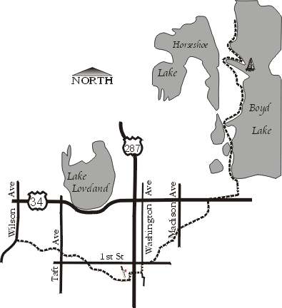
The northern terminus of the trail lies near the north end of the
lake. From the parking and picnic area at the end of the park road,
it starts by closely following the shoreline. After crossing the park
road (1.2 miles), it temporarily veers away from the lake. Soon it
recrosses the road, merging with the trail in the popular beach area
(1.8). Mind your speed among the crowds on the beach.
When the trail splits, follow the left fork along the shore. Slowly
the trail swings to the west, finally crossing a lake outlet at mile
2.7. As it turns due south, you pedal by Heinricy Lake to the right.
Soon you find yourself in Seven Lakes Park (3.1), a city park with
trails looping through it. Stay to the left to cross the park.
Leave the park (3.8) by crossing 18th St onto Denver Ave. Follow
this side road until the trail cuts to the right (4.0), following
the canal under Eisenhower Blvd/US34 (4.2). On the opposite side,
the trail follows the canal through an open field bordered by
industry on the right.
The trail crosses Madison Ave at mile 5.0, then has its own stoplight
controlling bike traffic over the railroad tracks. You now pedal through
a residential district, following the canal between back yards and across
several side streets. Watch for the emu in one of the first yards you pass!
Once you reach the Civic Center (5.6), the trail curves again to parallel
1st St (5.8).
Bike route signs tell you to cross 1st at Washington Ave (6.0) Now on city
streets, you take Washington to the next street, and turn right on 3rd St SE
(6.1). This quickly takes you to Lincoln Ave, where things get dicey.
In downtown Loveland, US287 is split onto separate north- and south-bound
streets. Lincoln carries the north-bound traffic, but we need to head south
on the trail. When traffic is clear, jog south several yards on Lincoln and
quickly turn right into the continuation of 3rd St SE. (You will see the bike
signs once you turn.) The next cross-street is Cleveland (6.4), carrying
south-bound 287 traffic. Follow that south to the park on 5th St SE (6.5).
NOTE: on your return, follow 5th to Lincoln and take that north to 3rd.
Once in the park, the trail begins again (6.6), and immediately
branches. The left fork winds by the Larimer County Fairgrounds,
then turns east along the Big Thompson River. It crosses under US287
(7.4), but no ramps provide access to the highway. This spur enters a
wild area before quickly hitting a dead-end (7.5). If you're lucky you
may glimpse wildlife here -- I saw a deer trotting right at me when I
scouted the trail.
Soon this spur will extend to replace the above-described tangle
with US287. An extension to 8th St SE was being staked in April
1999, and should be completed before summer ends. Completion of
the path to 4th St SE and Washington (where the route would run
a short distance on city streets) is expected in the fall.
The main trail continues straight ahead from the fork. It crosses
over the Big Thompson, then under the railroad tracks (6.7). To the
left are reclaimed gravel ponds, to the right a river that looks more
like an irrigation ditch. After passing under 1st St (7.4), you enter
Centennial Park, though little of the park is visible from the trail.
As you proceed west, the terrain gradually grows wilder. After diving
under Taft Ave (7.9) the river once again resembles a river, with gravel
bars and stands of trees. The open space surrounding the river becomes
wide, and houses no longer crowd the trail. The trail feels as remote
as it gets inside the city. A side trail at mile 8.3 runs 0.3 miles
into a nearby neighborhood, crossing Dotsero and Bushnell Streets
in the process. The main path follows the river, ending at Wilson
Ave (8.7).
WHAT ELSE:
Loveland's most noted annual event is early August's Sculpture in
the Park. Two hundred sculptors come to Benson Park each year to
sell and display their work for thousands of visitors. Creations
can be had for as little as $400, or you can drop $60,000 on the
perfect piece for your dining room.
The town is big enough to offer a large selection of hotels,
motels, and restaurants.
This trail is excerpted from the book "Trails Away / Colorado". For more information,
see our books page.
Return to the home page.